
NAME
m.toporeach - Topology calculation for reach segments
KEYWORDS
vector, topology, linear units, MHYDAS
SYNOPSIS
m.toporeach
m.toporeach help
m.toporeach [-c] input=name output=name [gu=name] ID=string [IDGU=string] [colwidth=string] [colheight=string] dem=name [outlet=float] [slop_val=float] [ID_OUT=string] [UPST_OUT=string] [DNST_OUT=string] [LOW_OUT=string] [LEN_OUT=string] [WID_OUT=string] [HEIG_OUT=string] [SLOPE_OUT=string] [PCSSORD_OUT=string] [COMMENT_OUT=string] [GUID=string] [--overwrite] [--verbose] [--quiet]
Flags:
- -c
- use the option outlet to find the outlet segment (must use the column 'outlet'); otherwise DEM is used
- --overwrite
- Allow output files to overwrite existing files
- --verbose
- Verbose module output
- --quiet
- Quiet module output
Parameters:
- input=name
- Input line vector name
- output=name
- Output line vector name
- gu=name
- Input ground water vector name
- ID=string
- ID reach column name
- IDGU=string
- ID Ground Water column name
- colwidth=string
- Width reach column name
- colheight=string
- Height reach column name
- dem=name
- Input DEM
- outlet=float
- ID value of the outlet segment
- slop_val=float
- Replacement value for null or negative calculated slope (must be > 0; default value is 0.0001)
- ID_OUT=string
- id OUTPUT column name
- Default: SELF_ID
- UPST_OUT=string
- UP Node OUTPUT column name
- Default: UPST_NOD
- DNST_OUT=string
- DOWN Node OUTPUT column name
- Default: DNST_NOD
- LOW_OUT=string
- Low RS id OUTPUT column name
- Default: LORCH_ID
- LEN_OUT=string
- Length OUTPUT column name
- Default: USR_LEN
- WID_OUT=string
- Width OUTPUT column name
- Default: USR_WID
- HEIG_OUT=string
- Height OUTPUT column name
- Default: USR_HEIG
- SLOPE_OUT=string
- Slope OUTPUT column name
- Default: USR_SLOP
- PCSSORD_OUT=string
- Process Order OUTPUT column name
- Default: PCSS_ORD
- COMMENT_OUT=string
- Commentary OUTPUT column name
- Default: COMMENT
- GUID_OUT=string
- ID GU OUTPUT column name
- Default: EXHGW_ID
DESCRIPTION
m.toporeach allows the user to calculate oriented topology of linear units (RS MHYDAS). Linear network can be optionally created by the m.seg and m.extractlineseg scripts.
NOTES
Input and output layers
The input layer can be created by m.extractlineseg, but m.toporeach script can also accept simple line layer (just be sure that in that case layer geometry and topology are correct; use m.network script to verify). The output layer will contain the following columns (columns are created during this process):
- $ID_OUT : unique Object ID
- $UPST_OUT : UpNode ID
- $DNST_OUT : DownNode ID (m/m)
- $LOW_OUT : Down Hydro Object ID
- $LEN_OUT : Length (m)
- $WID_OUT : Width (m)
- $HEIG_OUT : Height (m)
- SLOPE_OUT : Slope (m/m)
- $PCSSORD_OUT : Object Process Order
- $GUID_OUT : ID unit for underground exchanges
- $COMMENT_OUT : Commentary
The segment outlet can be provided by user with flag -c and option outlet or automatically by DEM (algorithm will find the dangle segment which have the node with the lowest elevation).
Topology with GroundWater units can be processed with GU and IDGU options.
If input layer have width and height segment information, they can be provided using colwidth and colheight options; these attributes will be transfered on the output layer.
If the user wants to have xml files or fluidx files for the OpenFluid version 1.5 or superior, please use m.definput script to create these files.
Calculated slopes are always positive (no negative or null value); for negative or null slopes, user can manage its own value by slop_val option (default value is 0.0001).
EXAMPLES
Oriented topology calculation for seg_reachs
Outlet segment provided by Raster DEM elevation. Width and height of the reachs are provided too.
GRASS 6.3.0 :~ > m.toporeach input=seg_reachs output=seg_reachs2 ID=SELF_ID dem=elevation colwidth=width colheight=height
|
|
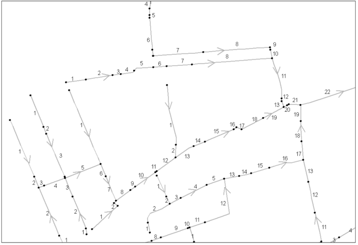
Oriented topology with Process Order labels
|
Oriented topology calculation with user's outlet provided
GRASS 6.3.0 :~ > m.toporeach -c input=seg_reachs output=seg_reachs2 ID=SELF_ID dem=elevation outlet=18
Oriented topology calculation with Ground Water units provided
GRASS 6.3.0 :~ > m.toporeach -c input=seg_reachs output=seg_reachs2 ID=SELF_ID dem=elevation outlet=18 GU=GroundW IDGU=Ident
SEE ALSO
m.seg, m.extractlineseg, m.toposu, m.definput, m.network
AUTHORS
Michael Rabotin, UMR LISAH, Montpellier, France
rabotin@supagro.inra.fr
Last Changed: 23 January 2012
Main index
Copyright UMR LISAH OpenFluid